Last weekend my brother Greg and I made our annual fall backpacking trip. Or in this case semi-annual, as last year I didn't have enough vacation. We met up early on Thursday in the small desert town of Mojave CA, and drove from there up Hwy 395 to the tiny town of Independence for this years trek, stopping in Lone Pine at the ranger station to get our Wilderness permit as always. Leaving 395 in Independence we head west towards the looming Sierra Nevada mountains, in all their majesty.

This is the view as we head towards the mountains. I'm
always surprised heading in, as when you are driving along 395 it just seems
like there's the mountains with no access whatsoever. If you peek at the
far right of this photo you can barely see the road switch-backing up towards the trail-head. The Sierra Nevada mountains are just amazing to me!

We drove up to the Onion Valley trailhead campground after getting our permit, and spent the night car-camping at around 8500 feet (to give us a brief altitude acclimation period being as we live at sea-level). Our destination: the Onion Valley and Kearsarge Pass/valley. Greg is on the left, I'm on the right. (note: this picture was actually taken at the END of our trek, as we FORGOT to get our usual starting photo. I think we look pretty good after 4 nights of sleeping on the dirt!)

This is an attempt at an artsy photo. I just loved how the early morning sun lit-up this large pine tree (seen guarding it's tiny sibling deep in it's shade at the base).

As always, we MUST get an expedition portrait as we officially enter the wilderness. Do we look like intrepid explorers or WHAT!

Looking back from the trail you can see the trail-head parking area, the road switch-backing down into the Owens Valley, and FAR below the tiny town of Independence, CA. Far across the valley are MORE mountains, and on the other side of those is Death Valley National Park. There is a foot-race every year called the Badwater 1000 (I think), and it starts in Death Valley, and finishes (officially) at the Mt Whitney portal trailhead (around 8500'). Most of the runners choose to continue right past the finish line to unofficial finish which is at the highest point of the continental US, the peak of Mt Whitney (14,497' I think). Many years ago when we were hiking Mt Whitney the race was finishing and we got to briefly chat w/ some of the crews as they waited for their runner to come by (so the run goes from the lowest to the highest points in the US).

This is the first REAL lake we come upon: Gilbert lake (I say REAL as we have already passed the tiny blob of Little-Posthole lake, which is barely big enough to be considered a lake).

Up next is Flower lake. It was in this Inlet that I caught the first fish of the expedition: a reasonable size brook trout (which was still quite small....maybe 1/2 pound at the most).


At Flower lake we saw these two deer, and they were most assuredly NOT
afraid of us. But why would they be? There is no hunting up here, and
most hikers/backpackers will only shoot them with cameras anyway. They
were curious, but then went right back to grazing. The doe is the first shot, and you can barely see the spike-antlers of the young buck in the bottom shot.

And this is Heart Lake. It's off the main trail, and we had quite a traverse hike WITH full backpacks to get here. This is where we set-up our base-camp for the duration of our trip. This shot is the view you get as you come up from Flower lake. The elevation here is 10,800 feet.

And this is the first fish caught IN Heart lake. Turns out there are only about 8 fish in the entire lake (as far as we know, they didn't seem too interested in being caught, that's for sure!) It's a nice little trout.

The view the next morning as the lake is completely still. The reflection is just incredible!

Now we are on the trail towards Kearsage Pass and it's lakes. This shot is looking back down at Heart lake, and if you look on the left in the outcrop in the middle/top of the "heart" in the small clearing, you can just see our tiny green tent at base-camp. This is just about as close as the main trail comes to heart lake.

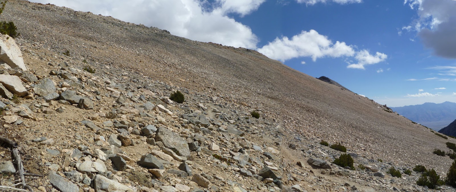
Continuing up the trail towards the pass we hiked along this 'scree' field. It's HUGE! You just don't get views like this in very many places. The beauty and desolation is amazing!


Yours truly at the top of Kearsarge Pass, (elevation 11,800 feet). This view shows the Kearsarge lakes on the left, and Bullfrog lake on the right.


Pack-mule trains are fairly common in the Sierras, as they take paying customers deep into the mountains with huge amounts of gear. We are actually in Kings Canyon National Park now, and have been from the moment we went over the pass. Here you see them working their way up the switchbacks.

At the base of the first Kearsarge lake we see the robber of the daytime: a high Sierra marmot. They are quite large (about the size of a small dog..probably around 10 pounds) and have no fear: they will rob your backpack/camp right before your very eyes. THEY are why you need to keep your food put away in bear-cans or bear-hangs at all times. Luckily we didn't see ANY robbers at our base-camp, as I guess people don't stay there very often and there's just not much to eat. We also didn't see any bears OR signs.

Greg fishing ahead of me on Kearsarge lake. Yep...just another high Sierra beautiful lake. Ho-hum.

Looking back at the Kearsarge Pass, which is near the right edge of the picture (near the right end of the picture). You can see the long trail heading to the pass.


THIS is a tiny Golden Trout, can't remember which of the lakes he was caught in. I just wanted a pic of one.

This is another of my 'artsy' photos. It's a Bristlecone pine, elevation 11,000 feet. They only live at high elevations, and the nastier the terrain it roots in, the longer they live. This one is STILL alive, as if you look close it still has some green in the back/middle area. The reputed oldest living (non-clonal) thing on the planet is a large Bristlecone Pine just north and across the valley on White Mountain called the "Methuselah tree". It's age has been found to be 4844-4845 years old (as they've done a core-sample for verification). They don't tell you WHICH tree it is on the trail (we've hiked it, and you can guess but aren't sure)...because if they did, some idiot would burn or cut it down.

Another artsy pic...this one is a totally dead Bristlecone. Even after they die, they take FOREVER to decay being as they grow SO very slowly that the wood in insanely dense (the rings have to be counted with a microscope). Even when the trees finally fall or branches break off, the wood just lies there on top of the dirt decade after decade.

Here you see first view of Charlotte Lake. We hiked over here on Sunday and on THIS day I was the one on fire catching fish. I quit counting at around 15, and it was AWESOME! (it was also my 52nd birthday, so I guess that's a good day to have the golden-fishing rod!) Somewhere near here is Charlotte Dome, a large rock dome that climbers pack in just to climb. We met 2 separate groups during our hike that were headed here to climb it.

Heading south on the John Muir Trail from Charlotte Lake towards Mt Whitney (only about 4 or 5 backpacking days away if we were so inclined). The JMT heads thru the valley to the left. Isn't the terrain back here just SPECTACULAR?

And here we have our "all packed up and ready to head home" picture at Heart Lake on Monday morning. It was a GREAT trip and I can't hardly wait to do it again!

Here I give you one final look: a panorama of the Kearsage valley taken from the pass.
Beautiful, just BEAUTIFUL!
I apologize that it took so long to get this posted...it was REALLY busy at work last week. We had a successful spacecraft launch on Thursday, and I was on the hook for all our equipment at the satellite control rooms (meaning I spent a 12 hour day playing Maytag repairman hovering in the area "on call" in case something broke).
And alas, summer is once again in the history books, and fall is here. School is back in session. Hang onto your hats...Christmas is coming FAST!
Cheers!
Thanks for the post and pictures, Matt.
ReplyDeleteAs you know I backpacked up there quite a bit in the mid-late 80s. Loved it! Your post brings back the memories.
I went over Kearsarge pass from Onion Valley, then picked up the PCT and headed south for an outnback trip. Went just beyond Independence pass I think (so long ago it is hard to remember now!) I remember climbing that last pass VERY slowly -- take 3-4 steps, pause to breathe, 3-4 steps, pause... I ran into fishermen on the trail but never fished myself. I also had a bear encounter on that trail -- woke me up about 1am rummaging around the campsite. I had hung all my food on the provided cable so no problems but I was terrified! A nearby camper had neglected to bury his coffee grounds though and ended up with a collapsed tent (but no harm fortunately). There were several spots along the trail in that area where there were cables or lockers to protect from bears; I always made sure to use them. A very beautiful area to be sure. Seems that I remember passing through a spot where all the timber had been knocked down, perhaps by an avalanche?
I also remember camping my first night over the pass near where one of the packer camps was, and having to listen to their boom box all evening. Boy was I annoyed by that! Guess their customers didn't want THAT much of a wilderness experience!
I always intended to do the Rae Lakes loop (he-he) but never actually did, although did go along that end of the PCT for some distance too.
Rae
Rae, when we were hiking and I saw the sign for Rae Lakes for the first time I thought "I wonder if Rae ever went up here?"...(knowing you have hiked up around here before)...was chuckling to myself over how clever I was to think of that. It is really beautiful up there...anywhere up there...everywhere we've been thus far is similar but different...I just LOVE it up high.
DeleteThankfully of my 2 brothers and I, it seems I'm the only one who has ever had ANY effects of alt sickness...and that was years ago when we drove from sea level to the White Mountain research station (it was open house...it sits about 8000' or so) and after we toured the station we rode our mt bikes to the top of White Mt (or at least very close...there was still snow so we had to ditch them about a half mile from the top and hike it in bike shoes). I had quite a headache going but survived...since then we've always gone only up to around 8k or so and spent a night...really helps, even tho we are huffing and puffing the next day as we start the pack-in. Didn't have even a shred of problem this time.
We are refining our technique, and next year hope to do a point to point (carrying ALL our gear each day)...however as we get older we need to lighten the packs...more each year...by the time we actually do the P2P we will only be able to carry about 10 pounds I'm afraid (GRIN!)
My brothers are both engineers, and like data...Greg keeps an excel spreadsheet EVERY YEAR of every single thing we both carry in, what we used, what we don't...and I think we have it down to about as good as we can...just need a lighter sleeping bag (I don't yet have down) and then lighter tent (or tent substitute...most likely some form of home made Kevlar bivy-bag/cover combo)...and we are a go for P2P. And some lighter food...
Oh, and the only time that I had trouble with marmots was on the climb of Mt. Whitney. They chewed a hole in my tent!
ReplyDeleteI always had a little trouble with altitude sickness, even at the 8000 ft. campgrounds, but really had an issue on Mt. Whitney. I stopped and camped at the 12000 ft area, was so headachey and nauseated that I just crawled into my tent and went to sleep for an hour or two. Thank goodness for Pepto-bismol -- I always took it along!
Rae
We've carried a bear can every time cuz they are required...however have never seen any bears (yet, it's only a matter of time). I also do a bear hang cuz all our stuff doesn't fit...you really have to be careful...my friend at work says a guy he was with had a container of icy-hot in his pack and a bear tore the pack apart at night and ate the icy hot...the rangers say ANYTHING that smells must be canned/hanged...chapsticks, toothpaste, whatever...I wouldn't have believed icy hot...that must have been interesting...talk about a cast iron stomach! Never yet had a marmot prob, but they are typically around, just give them a chance and you'll regret it.
DeleteWhat an amazing trip! Thank you so much for sharing your narrative and breathtakingly beautiful photos with us. That is such a gorgeous area of the country. My husband and I have done some hiking there and my favorite thing is coming around a rock face to have a beautiful lake revealed beyond. Your photos take me right back there - I can almost feel the crispness of the air.
ReplyDeleteRae, I get terrible altitude sickness on my first day at significant elevation too. UGH! I discovered this when we were camping at the highest campground in Rocky Mt Nat'l Park. I thought my head was going to explode. Didn't help that we drove up the mountain, put the tent up, and then took off for a hike. I've learned to not exert myself for the first day and to try and sleep 1/2 way up for a night before.
School is back in session and kids' activities are in full swing - gasp! I'm just trying to keep up and get in bed before 2 am. I was thrilled to discover this great post when I had time to visit the IA :)
Camping this weekend with my extended family! Hoping for good weather.
-Janann
Hey JD..one of the things that always strikes me is how BLUE the sky is, and how white the rock is...and then there's the night sky...THAT alone is worth the price of admission!
DeleteI was wondering how things were going...you weren't involved in that big strike? (it was Chicago, wasn't it? Sometimes I suck at current events, other than knowing something is happening somewhere)...I'd imagine getting back into the full swing of things is brutal...but once you get going and you hit your stride it's all good after that. I'd sure like a job where I get a month or more off every year..but I'm guessing you earn it...
I taught Electronics in the Navy for 4 years, and that was hard enough (but very cool in some ways)...and I taught predominantly 18-19 yr-olds (who being in the military were NOT about to give me any lip WHATS-SO-EVER, like a Public School teacher gets...they'd pay DEARLY)...not sure I can imagine younger kids...(the Arnold movie Kindergarden Cop cracks me up!)
Hang in there!
Beautiful pictures, Matt! now THIS is a tradition worth keeping!
ReplyDeleteBarbara
This comment has been removed by the author.
DeleteHey Barbara...it's prob my fav tradition...only wish my other brother wasn't so far away...(he's in Texas now)...I did both Whitney hikes with my bro's...it was prob 2 of my fav times I've ever had! The first one they had both been up before, it was my first...we detoured on the way up off to the left and ended up boulder-hopping on house-sized boulders across an entire mountainside..it was AWESOME!
DeleteThen the 2nd year we did the hike at night, trying to make it for sunrise...some strange stories on that one, suffice to say we were just a bit short on time so detoured to the top of Mt Muir (another 14'er) for sunrise, then on to Whitney summit after that for hot Lipton cup-a-soup and instant coffee.
Ahhh...good times, good times!