Day 8: Samuel P. Taylor St Park to Half Moon Bay State Park

 |
For backpacking the original stove is perfect, and knowing that we need to have our entire trips worth of food with us from the start we only carry dehydrated meals. For road-touring that isn't the case...we (hopefully) have a few chances each day to stop and shop for food, whether at an actual market/grocery store or gas stations/mini-marts/etc. This really helps keep the weight of 'stuff' that we are carrying on our bikes much more reasonable. Anyway, this is a typical grocery run for me...we split a box of instant oatmeal's (I use 3 packs for breakfast, Greg uses 4), a box of Pasta Roni with a can of chicken for dinner along with a pack of instant potatoes (we split the chicken and potatoes each evening as the large can and the bag of taters is too much for one person), and the snacks I eat all day while riding is some sort of gummy-candy (that I keep in a bag hanging on my handlebars so I can eat them while I ride all day long).
This particular food-stop also had fresh coffee and cookies, always nice to have a little coffee-break / snack an hour or two into the ride.

Today is the day we cross the Golden Gate Bridge and then ride thru/around San Francisco to get to Half Moon Bay (the picture above is when we could first see the city). What I don't have is any pictures from earlier this morning. Of note: in the small town of Fairfax (just past San Anselmo) we finally rode by an open bike-shop. Greg took his bike in and the mechanic put it right on his rack and worked on his shifting issues.
All morning long we had been seeing road bikers....singles, twos, and some fairly large groups. Turns out this route we are on is a VERY popular road-riding route in this area. The roads and shoulders were pretty great for the most part. And the closer we got to Sausalito (and the GGB) the more bikers we saw.

So as we were nearing the GGB there were road closure signs and a detour. One of those roads was on the route that I had made on the RideWithGPS course for today, taking us directly to the bridge. Not knowing the area or roads we followed the detour up and around thru the hills north of the GGB, and finally bringing us to the GGB tourist-viewing areas north of the bridge.The climb up was an effort, but the views were spectacular (and had we followed the easier route we never would have had these views). This pic is from where our detour initially joined the road going down to the bridge. You can see the bridge somewhat off in the distance.

Now THIS is a view! This is on the road heading down to the bridge from our detour...pretty fantastic!

HERE is where things got interesting (ie:scary). We are just starting over the bridge on the bicycle path (the ocean-side of the bridge....pedestrians have the bay-side of the bridge). That's Greg up ahead 15-20 feet past that first light-pole. In this shot there is only one other bike in view. That was NOT how it was most of the way.

I'm probably half-way across in this shot. Again, it appears the bike-path is almost deserted. I guess the bikes come in large groups. MANY of the bikes coming across are on rental e-bikes (Electric). Not to be knockin' e-bikes, but what that allows is people who aren't bike riders at all (ie: they may have little to none of the skills earned by lots of time on 2 wheels). AND there was a 20 to 30mph cross-wind, which was coming at us from the ocean-side (the right).
Added to that mix was all the wanna-be-road-racers mostly coming back into the city (same direction that we are going) who are riding like maniacs zig-zagging thru the e-bike masses like there is money at stake in a race. It was pretty crazy at times, definitely a bit terrifying for us on loaded bikes not riding at warp-speed, just trying not-to-crash as the cross-wind gusts would hit our bikes like we were sail-boats (with all our packs acting like sails).

Here I'm at a little 'pull-out' so I could safely take pictures without my bike sticking out into the bike-lane. This shot is looking back to the north. There are roads visible higher up in those hills on the right of the shot...that's the way we came down after our detour.

So somewhere on the bridge I got past Greg (I think he was taking pics too), and here he is coming off the bridge. I think we both felt like kissing the road after we got off the bridge.

Here we had FINALLY found our way from the bridge-bike path and finally under Hwy 101, getting us to the bike-path that goes west across the north-side of the city (where our RWGPS route has us going). It was a bit stressful getting here let me tell you...my Garmin 810 (the only navigating unit we had as Greg's Garmin 800 died way back in the Avenue of the Giants) didn't really show just HOW were supposed to get over here from the bike-path on the bridge. And the foot and car traffic was crazy! Not to mention the huge quantities of bikes.

A nice lady took this shot of us looking back at the bridge and to the north. Now we just need to get thru/around the city.

Here was our lunch-stop in the city...a deli right along our route. I'm holding up my chili-polish-dog in the picture...isn't that a truly San Francisco lunch...a Deli-dog? (with chips)

Here we've rounded the corner (and got off the actual city streets it took to get here) and are heading south...hooray! I've been to SF many times (none lately tho)but never even knew there was a LARGE beach right here on the north-west side of the city.

One of the scenic little bays we went by as we were now south of SF and nearing Half Moon Bay. North of this stretch one of the guys I used to work with , Michael (who has been working out of Sunnyvale for a while now) drove up to HMB, parked, and came north along our route on his road bike to meet us and then ride back to HMB with us. He had a pretty good tailwind, where-as Greg and I had a pretty tough headwind. So he got up to Pacifica well ahead of us getting down to it, so he hung out on the beach for a while until we finally rolled by.


This is Michael...(he still has to drive back to Sunnyvale and get to work tomorrow...it's currently a Sunday).
End of Day 8 totals:
445.47 miles, 29,688' of climbing
Day 9: Half Moon Bay to New Brighton State Beach (Santa Cruz)

Day 9 stats: 58.76mi, 2900' climbing, 4h 54m moving time

Occasionally we were able to get a hot breakfast early on our route...usually that wouldn't be actual breakfast but just coffee and maybe a pastry if we were lucky. Today we found a Golden Arches just a mile or so from our route. Pancakes, Sausage McMuffins, coffee?? YES PLEASE! (we've been eating instant oatmeal every morning at our campsite).

A shot looking south on Hwy-1 en-route to Santa Cruz. Right here the coast looks very much like it does back on Vandenberg Space Force Base (VSFB) / the Central-Coast area.

Wide-angle lens shot of another little cove.

The beaches in this area (north of Santa Cruz) are vastly different than the coast in the Big Sur area.

I've actually ridden a bunch of the coast we are on today, years back when I did a road-ride loop on Skyline Rd and down to Half Moon Bay, then south on Hwy 1 (where we are right now), but I turned east at the little town of San Gregoria headed back into the hills, where today we continue Hwy 1 to Santa Cruz. That's Greg stopped ahead of me taking a picture.

Pigeon Point Lighthouse. I"m still a ways off for this shot.

So the lighthouse is actually to the closed to the public due to unsafe conditions. The big iron ring under the top has rusted bad and part of it fell off. They had to remove the 4-ton lens (for it's safety), and it's now living down in one of the other buildings.


This is the 4 TON Fresnel Lens that is the heart of the lighthouse. It comes in sections, and the entire thing had to be taken apart to remove it, then re-assembled here at it's storage location. Each part of the lens (each piece of glass) gives off it's own 'beam' of light. The beams can be seen for many miles.


On this informational sign there is a picture of the actual light coming off the lens...you can see the focused 'beams' that help the light to be seen from such distances that ships can use it to navigate.


Day 9 dinner excursion
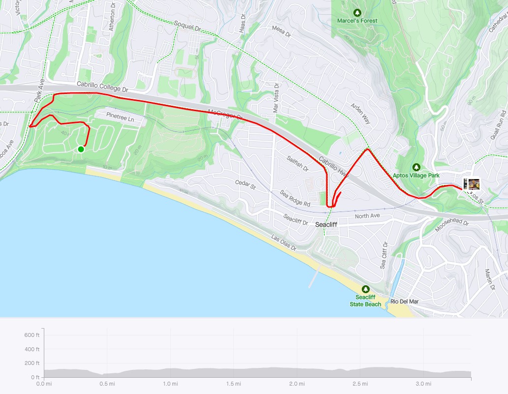
The STRAVA Map of our short (but AWESOME) dinner excursion. Greg wasn't totally onboard with the 'dinner out' plan, but I talked him into it and he was glad he came.

This was our 'dinner out' location: The Aptos Street BBQ"...oh YEAH!!! I've been here once before and it was awesome, and well worth the 3 mile ride from camp. Thankfully it's a Monday...had this been a weekend we would have had a hard time getting in as the place would be jammed. All I can say is that if you are EVER in the Santa Cruz/Capitola/Aptos area, this is a place you want to stop for dinner (or lunch) if you like barbecue and beer.

My dinner...a 'regular' size BBQ Beef sandwich, cole slaw, and a half-salad with a TASTY beer! Other than 2 slices of Pizza last night with Michael (they were ok but nothing to write home about) this is the first seriously tasty meal of the trip.
 |

And the menu. Hard to decide what to get, it's all good!
End of Day 9 totals (including Dinner-Out round-trip):
511.08 miles, 33,004' of climbing
Day 10: New Brighton State Beach to Pfeiffer Big Sur State Park


Not very far south of Santa Cruz, this is the Moss Landing Marina. I took this picture, and moments later as we were starting to ride again Greg shouted out the dreaded "FLAT!". Yep...a flat tire...the first of our trip (and the only one too...amazing considering all the debris we rode thru on the shoulders).
Sadly, getting the rear-tire off his bike wasn't easy-peasy. His rear rack is mounted to the bike with clamps to the seat-stays and then uses the axle-skewer with spacers to connect the load-bearing vertical part of the rack to the bike. So first you have to remove the rear pannier bags, then pull the skewer out completely trying NOT to lose any spacers and washers (we only lost 1 washer out of the 4 when the repair was done, which was a minor miracle). Then you fight the rear wheel off the bike (with the rack still partially attached to the frame). THEN you can fix the flat, re-fight the wheel back into position, then fight the rack with the washers and spacers back onto the skewer, tighten it all up and finally put the panniers back...and viola...tire repair complete.

So this is a pan of Monterey Bay...usually I can't see any evidence of picture-merging on phone-made pan pics, but this one came out horrible...you can clearly see a joining mid-pic. I don't know why I didn't just use the wide-screen mode...usually Pans are very nicely done by the camera.

We are still on the PCH, just south of Carmel now. This part of the coast is really beautiful! To my right just a few feet is an artist painting this same view.

Not very far at all from the last shot. The road below on the left isn't part of Hwy-1 (PCH) though it must be wonderful to have a house down there...how beautiful it is here!

The coast highway we rode along today (and tomorrow) are our favorites of the trip.


Just one of the many highway-construction 1-lane sections of the PCH. I'm off the side and in front of the flagman, with the waiting cars lining up behind me. This is easier for me on a loaded bike to be here at the front and wait until all the cars have gone by, then I can jump in behind the last car and pedal across the construction zone, hopefully not holding up the other sides waiting cars too much.

How about THAT view! This is a panorama of the view.

Same location as the last shot but in normal mode.

One of the beautiful arch-bridges on the PCH, this one is the Rocky Creek Bridge.

Looking back to the north.

The PCH along here is a pretty expensive piece of highway. Look at this section, how much work (and money) would it take to make it? A lot I'm betting.

This is the famous Bixby Bridge. Same construction type as the Rocky Creek bridge but bigger.

Looking back at the Bixby Bridge.

Getting close to our destination for the night...that's Point Sur sticking out on the right off in the distance.

Getting real close to Point Sur now. Our campground isn't too far south of that.

And there it is...Point Sal. The Point Sal lighthouse is up on top. That would be a great site for a medieval castle...you wouldn't take that by force!

And just south of Point Sal is the site of the old Point Sur NAVFAC (Naval Facility). It was one the original West Coast SOSUS Stations (a small one, not nearly as big as the old Centerville Beach site that was near us back on Day 2). Unlike Centerville, all the buildings are still here (as far as I can tell).

The Point Sur NAVFAC as seen from just a few hundred yards south of the entry road pic. Here you can see how close it is to Point Sal, which is just to the north (that's the road winding up to the lighthouse you can see in the upper right).

And just like that, we are here. It's been a really fun day of riding (once we got past Monterey that is).

At this camp we had to get creative for our clothesline (being in a State Park with redwoods, we can't tie it to the trees)...however there are these square concrete posts all around the hiker/biker area with steel rings set into the concrete (for us to chain our bikes to, maybe they've had some bike thefts here?). So we leaned our bikes against the outside of the posts and stretched the line between the bikes, pulling it pretty tight. Even so it sagged pretty low to the ground in the middle but it gave us enough line for both of us to hang both our sets of wet riding clothes.
End of Day 10 totals:
583.9 miles, 37,377' of climbing
Day 11: Pfeiffer Big Sur State Park to San Simeon State Park


So today's ride started out with a pretty good climb (about 800 vertical feet) right from the start (and it was quite chilly in the marine layer too). As we climbed out of the layer at the top of the climb we found a small market with hot coffee and pastries...took this pic as I was drinking my coffee and warming up.

Here the PCH has some altitude as it was cut into the rugged mountains above the surf.

Looking back to the north you can see the PCH winding along, roughly following the shoreline.

One of the few straight stretches of road. It's pretty twisty along the coast.

The PCH just goes on and on down the coast.

Redwoods are all over the place on the PCH, mostly in smaller groves. This sign talks about how the Coastal Redwoods are the tallest trees on the planet, mostly due to their ability to pull huge amounts of water out of the air and the huge amount of water-vapor that collects on the needles and then falls to the ground, perpetually 'watering' the trees. They can grow to be over 2000 years old, tho there are very few of the old-growth-trees still standing after the heyday of the logging industry over the last 200 years along the coast.

Didn't even know we rode over another arch bridge (this one is a double!) until I was able to see it from the south. From the road surface it's just more concrete-road with nice walls.

Another shot looking back north. The coastline is just so amazing here!

Looking south again, it just blows my mind all the rocks sticking up out of the water and how far out some of them are. Imagine how big that one in the top-middle of the shot really is.

Another descent...the coast-road is always climbing or descending as it winds it's way around all the small canyons coming down to the coast. In the distance you can see a small concrete structure jutting out from the mountain...thought I'd get a better shot of that.

Here it is...almost a European-style tunnel protecting the road from landslides. No idea how old this is. I know there have been several bad slides in recent years, and the road was closed for quite some time a few years back for the repairs...maybe this was it? It's definitely an expensive piece of road (the PCH from Monterey to San Simeon).

Still some good rugged coast miles yet to go.


A pretty sweet looking little cove. Interesting that huge rock jutting out is some type of white rock, unlike most of the black volcanic rock most of the coast is made of.

The beginning of the end...that point jutting out is Ragged Point. After that the road descends down to the flats towards San Simeon. Ragged Point is pretty much the end of the STEEP rugged coastline along the PCH.

Yep...this is it. Actually this is quite the 'tourist-trap' spot. Restaurants, small shops, etc...almost nothing whatsoever here for bike-touring folk tho. The tiny market doesn't even have Gatorade! Lots of the fancy (ie:expensive) Monsters and other chic energy drinks tho. Back in late May when I was attempting the Tour de Los Padres on my gravel-bike I came thru here on the morning of day 2. I actually bought a Monster Java Triple-shot something or other (the first and only foo-foo-energy-drink I've ever had) as I was seriously dragging after a huge 1st-day (almost 11 hours on the bike...and day 2 would end up being almost 12 hours before I threw down my tent and crashed).

Looking back up at Ragged Point. It was on the descent that we realized we had a wicked tail-wind! FINALLY!! (was wondering when the central-coast-winds would be in our favor). Even on the flats we could easily holding over 18-20mph on our heavy bikes, riding along in near silence other than the hum of the tires on the pavement. Tailwinds are AWESOME!

Stopped at the world-famous San Simeon elephant-seal-breeding-grounds beaches.

A wide-angle-shot of one of the main beaches...considering how early in the season it is I'm surprised that there are so many of them already here.

Day 12: San Simeon State Park to Pismo State Beach (North Beach Campground)


Greg just cruising along with another day's awesome tailwind heading south from San Simeon! And we have nice wide shoulders here too!

Here's where our road turns away from the coast for a bit...Morro Bay (and the famous Morro Bay power plant triple-stacks, along with Morro Rock to the right).

Heading inland now from Morro Bay, I never knew these wetlands existed! The birds must love it here!

Now we are back along the coast at Pismo after having gone inland and around the entire point that has Montana de Oro State Park, the Nuclear Power Plant at Diablo Canyon, and also the city of Avila Beach.

Had to make the obligatory stop at the Pismo Beach Pier.

And we have arrived at our stop for the night...the LAST night of the trip (boohoo).

The campsite at Pismo. This is a HUGE campground!

Greg photo-bombed my selfie while making dinner. It got quite chilly as the sun was going down.

I'd never seen an RV like this before! The lady who owned it (chatting with the small group of lookie-loos) sounded Dutch. It definitely is a conversation point.

The other side of the rather odd looking RV.

And how about this trailer-style camper? Quite the military/rugged-look to it.

And finally...a poetic picture symbolizing the end of our trip, sunset on the beach.
End of Day 12 totals:
707.68 miles, 44,841' of climbing
Day 13: Pismo State Beach to home (Santa Maria)


Not very far from Pismo we found JUST what we were looking for...a coffee shop!

On the road after our coffee and pastry stop we caught up to Piper. We've been leapfrogging with her and another guy (Alexy) the last few days. She was actually in the coffee shop when we stopped. She's riding the entire coast (Canada to Mexico) on a borrowed bike (her moms) with almost entirely borrowed (tent, etc). She's a recent college grad doing a bucket-list ride before starting work.

Here's Greg chatting briefly with Piper before we kick it up a notch and cruise for home. She just rides along at her own speed, usually getting into camp many hours after us. She doesn't have a master plan, she's pretty much making her plans day by day. I actually felt sorry for her over the next few days as today was the mild-beginning to a pretty ugly 'heat wave' that covered several states. By tomorrow it will be at or near triple digits even on the coast. Her continuing trip south to San Diego must have been simply sweltering.
I'm really glad I decided to stop (I originally wanted to go all the way to Mexico even tho Greg was going to head home from the Lompoc/Surf Beach train station), but to do that I would have had to take even more days off, and going thru the city (LA/Long Beach) over Labor Day weekend during a heat-wave would have just been miserable.

Past Guadalupe heading south on Hwy 1, cruising easy with the tailwind on mostly flat roads. I think this tree shows you that there is a pretty fair amount of wind here...it literally sculpts the trees.

I realized that I hadn't taken a single picture of a Hwy 1 sign this entire trip! Rectified that in the nick of time! (we are just a few miles from my house now).

And we are done...standing in my driveway for this final shot. What a wonderful vacation this has been, and I was SO HAPPY that Greg was able to get the time off to ride it with me! Dave (my other brother) wasn't able to ride with us, but he was with us in spirit, and following us via my SPOT tracker-map the entire trip...there were lots of humorous texts to/from him down in Houston over the course of the trip.
End of the trip totals:
737.04 miles and 45,970' of climbing over 13 consecutive days of riding.

And finally, the SPOT (Satellite POsition Tracker) map of the entire 13 day ride. The red dots (with a black dot in the middle) don't mean anything that I can figure, other than to show where the track was at some point of that days ride (there were LOTS and LOTS of update points...my SPOT unit sends an update every 10 minutes when it's in 'track' mode). Each days actual ride was a bit less than the distance between any 3 dots. That gives a bit of perspective of just how far each days ride was on the big map.
I've been slow getting through all of the photos - it looks to have been a great ride! It brings back memories of many (car) trips up that route, along with backpacking in the Ventana wilderness (I was 4 months along with my daughter!), spending Thanksgiving camping at Pfeiffer Big Sur, and many other stops along the way.
ReplyDeleteDid you notice Jade Cove somewhere along there? I still have a few pieces of Jade that we picked up there.
Of course I also remember crashing near Pismo on the first day of my only bikepacking trip (San Luis Obispo to Encinitas) and breaking my foot - the urgent care doc told me it wasn't broken, so I pushed on until in Central LA I just couldn't take the pain, so took the train from there back home. BTW the crash was NOT my fault!!!
And we did have (luckily only) one Santa Ana day riding from Guadelupe (IIRC), through Vandenberg to Goleta - that was REALLY hard, I didn't have enough water and was quite dehydrated before we reached Goleta!.
Hey Rae, glad to hear from you! It was a blast, hope to do it (or something very similar) again! I don't recall a Jade Cove...but if it wasn't on my/our planned stop list it would have had to jump out at us...thou now I am intrigued, and sad we missed it. We rarely get Santa Anna's up in our neck of the woods (Guad/Santa Maria/Lompoc)...usually they stay further south. Tho I have ridden in many brutal headwinds...but doing it on multi-day bike trips would be awful. Guadalupe to Goleta is a pretty good distance! Anyway, glad you are still out there and doing ok...didn't realize HOW MANY pictures I put in until I worked my way to the bottom...yikes, there is a bunch!
ReplyDeleteI hope you do it again, I am living (or re-living) my outdoor adventures vicariously through you ;) ;)
ReplyDeleteJade Cove is in between Carmel and San Simeon - as I recall there was only a small sign on the side of the road marking a steep trail down to the beach. It seems that collecting jade there is now forbidden.
BTW I had discovered that I made a mistake on my e-filed tax return last April, and so filed an amended return that the IRS received on April 19 and also sent in what I thought I owed. To date the IRS has not finished processing the 1040x!! Over 7 months!!!
Hey Matt, I left you a message in Facebook. I have a new email address & wrote it there. I hadn't even logged into FB since last summer so wasn't sure I could even get in but I did. Now I have to figure out how to change my email address in there. I am RETIRING in a few weeks (July 7th). Had planned to retire last Oct but financial crap last year made that impossible. Then, I targeted early June but my mom died in May & that made he miss some days right when I was trying to wrap stuff up so delayed one final time. Hope you email me soon. :)
ReplyDeleteHey Susie, I finally got into FB (also haven't been there in AGES) and have no idea where a message would be...can't find it...I had hoped to retire by the end of March but have put it off till probably Jan now...hope to hear from you, I'd given up on the IA...
DeleteOh, I HOPE you resusitate it! I'd love to chat about the Tour next month & will be able to see the stages of week 2 & 3 LIVE since my last day of work is Friday 7/7. Do you have my current email address? If you email me at the address, I can email you my new one.
DeleteLast year just fell apart, month after month. This year has in some ways been even worse (my mother died in early May) but I need to "enter the next chapter" of my life, retire, & hopefully enjoy the next several years (decades!) much more than the last few.
Hope you're doing well!
Hey Susie, just sent you a Message on FB, didn't see your message to me, nor can I find your old email addx...let me know if you see my FB message...
ReplyDeleteHi Matt! I got your email but am having some issues with my new ipad! I hope to be able to email you back by this weekend! I watched Peacock on my TV for the 1st time last night (which is no longer free as of MONDAY!) to watch the US Swimming Championships. It seemed like "regular TV" except 4-5 times, the screen froze for 5-15 seconds. Is that normal? Anhyoo, I found out this week that the TDF will only be on NBC channels too for the 1ST week, then the last 2 weeks will be solely on Peacock. Beginning next year, the entire thing will be on Peacock only & I HATE that so much of Olympic sports are now like this. I pay a freakin FORTUNE for cable & all these sports should STILL be there! Comcast OWNS Peacock/NBC but of course they want to gouge customers to pay/pay/pay.
ReplyDeletePlease, please post here during the Tour!